|
|
|
![]()
| Escambia County's network of numbered, county maintained roads has a clouded history. From what I have been able to gather, most of the numbered routes came under county control in the early 1980's. I am assuming that these routes were deemed secondary in nature, thus the reason for the change. If anyone knows why these routes were transferred from state maintenance to county maintenance, please email me at bbethea@ztel.com or bryan@roadgeek.zzn.com. Now, on to the data! |
County Routes 000 through
199
County
Routes 200 through 999
 |
Eastern
terminus: US 29 (FL 95) in Century Western terminus: FL 97 in Davisville
|
 |
Eastern terminus: Western terminus: |
 |
Northern
terminus: US 29 (FL 95) in Molino Southern terminus: US 29 (FL 95) in Brent CR 95A was the original
routing of US 29 through Escambia County. Locally the
road is known as Old Palafox Highway. Until recently, CR 95A still had it's original concrete paving. It was quite nostalgic to ride down this road. Alas, Escambia County replaced the concrete with asphalt in 1995. |
 |
Northern terminus: CR 196 in
Barrineau Park Southern terminus: CR 297A in the Pine Forest area I haven't been able to quite figure out this road yet. If it follows as the other routes in the county, then it must have been FL 97 at one point. FL 97 currently ends at CR 95A in Molino, well north of where CR 97 begins. But, a multiplex with US 29 from FL 97 in Molino (of today) southward to CR 196, then westward to the current northern end of CR 97 would do the trick, albeit a bit cumbersome. CR 97 meets CR 184 in Cantonment and multiplexes with CR 184 (unsigned) before heading south again to it's southern terminus at CR 297A in the Pine Forest area. |
 |
Northern
terminus: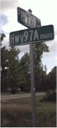 CR
99A in Walnut Hill CR
99A in Walnut HillSouthern terminus: CR 99 in Bay Springs CR 97A runs south from CR 99A in Walnut Hill then makes a 90 degree turn to the east at Enon. 4 miles later it ends at CR 99 in Bay Springs. (Note, my parents live at the intersection of CR 99 and CR 97A) At the right are the type of street signs Escambia County has spent the last four years installing at every intersection in the county. Prior to 1995, only intersections in the developed areas had signs such as these. Rural intersections had the white posts with black letters. (I am attempting to get a photograph of one of these cement posts to place here). |
 |
Northern terminus: Alabama state
line east of Atmore, AL Southern terminus: US 90 (FL 10A) in Beulah
Section 1 begins as the Alabama state line and runs south to a junction with FL 97 in Walnut Hill. From there it follows FL 97 (and it is a signed multiplex!) northwestward for about 1 mile. Section 2 begins where CR 99 leaves FL 97 and goes south to an end at CR 196. This section of CR 99 is known locally as McKinnonville Road. The intersection with CR 196 is interesting in that CR 99 approaches from the north while CR 196 approaches from east. The intersection is a "T", and neither route continues to the west. Actually, the road going west eventually turns into a dirt road and crosses a wooden bridge over the Perdido River into Alabama. Section 3 begins at CR 184 west of Cantonment and goes south to end at US 90 (FL 10A). This road is known locally as Beulah Road. It is possible to link sections 2 and 3 with muliplexes: From the end of section 2, route CR 99 along CR 196, then via CR 97 to CR 184. Follow CR 184 to get to section 3. That would work, but again, it seems convoluted. |
 |
Eastern
terminus: Western terminus: |
 |
Eastern terminus: Western terminus: |
 |
Eastern
terminus: Western terminus: |
 |
Eastern terminus: Western terminus: |
 |
Eastern
terminus: Western terminus: |
 CR
99 is divided into three sections. The first two are
somewhat contiguous, however, the third section is
nowhere near the first two.
CR
99 is divided into three sections. The first two are
somewhat contiguous, however, the third section is
nowhere near the first two.